John ROBERTSON of STRUAN House (SE of SA)
Along the Naracoorte-Penola Road, on a rise above the Mosquito Creek, there is a private burial ground around a granite plynth. On one side of the memorial stone are the words
In Memory of JOHN ROBERTSON
who was born at Dunachton.
Inverness-shire, Scotland, 1809
arrived in Australia, 1832
settled at Robertsons Plains, 1842
died at Struan House 31st March 1880.
And his wife SUSAN
who was born at Kinrara
Inverness-shire, Scotland, 1831
died at Struan House 27th May 1906.
John and Susan had come a long way, in circumstances as well as distance, from Dunachton (and Kinrara) in the Scottish Highlands to Struan in the South East of South Australia. By the time of his death in 1880, John Robertson was 'laird' of several adjoining sheep stations.
"At one period the estates owned and leased by this enterprising grazier reached a maximum of over 125,000 acres, while the stock carried, when the various runs directed from Struan were at their zenith, may be put down at 60,000 sheep, 2,000 head of cattle, and 500 pedigreed thoroughbreds."
('Struan, Narracoorte, South Australia: The Property of Alexander Robertson, Esq.', 1929, p 4, col A.) <history.pir.sa.gov.au/-data/assets/pdf-file/0008/152999/L4Doc3->
In 1842, the squatter John Robertson and his brother William arrived in the "New Country" from the Western District of Victoria. At the point where the Mosquito Creek emerges from the undulating limestone country and flows out into the flat Mosquito Plains, they "sat down" and built their hut and sheepyards.
The colonial government's Act for the Disposal of Crown Lands (1841-2) was a bare-bones revenue-raising exercise, belatedly recognising what was already happening by "imposing a yearly assessment on stock." In effect, squatters needed to pay only £5 annually . This fee licensed them to occupy and unlimited amount of land at an additional levy of 1 penny for each sheep, 6 pence per head of cattle, and 2 shillings and 6 pence for horses. Under this first system of land tenure the Robertson brothers were well placed. "Preoccupation provided security in territorial disputes with another squatter." Few could claim earlier arrival in this section of the South East than 1842.
(Leith MacGillivray, 1982, 'Land and People: European Land Settlement in the South East of South Australia, 1840-1940', Adelaide University, p 27.)<digital.library.adelaide.edu.bitstream>
In 1847, five years after John and William had taken up what had come to be known as "Robertsons Plains", a new set of regulations were issued. Stock numbers were now to determine the amount of land allowed to be held under an Occupation Licence -- 1 square mile (640 acres) for every 100 sheep and 6 square miles for every 100 head of cattle. Once again the Robertsons were well served. "Stocking the land rather than preoccupancy now gave prior entitlement to land." They had had five years of 'settlement' to bring in their sheep and build up their numbers.
(MacGillivray, 1982, p 39)
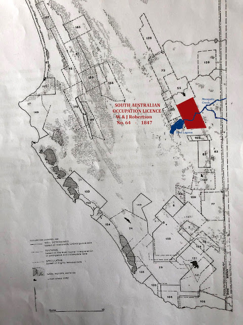
Despite the information on livestock carried, the authorities in Adelaide still had little idea where the squatters were situated and what their individual boundaries were. They had a list -- a list of licence numbers, licensee names, a rough description of location, and the amount of land they were prepared to 'pay' for. According to the list for 1847, Licence No. 64 was held by "William and John ROBERTSON of Mosqueto Creek" and applied to approximately 60 square miles. The map of Licences that follows is "based on the most logical interpretation of ambiguous and complete data." It is a reflection of the early years of the squatters "rush for the best land in the South East," not an exact copy.
(MacGillivray, 1982, p 40)
In 1850 the colonial legislature passed The Waste Lands Act. Annually renewable Occupation Licences were replaced by Pastoral Leases, which were available for terms up to 14 years. Maximum rent was £1 per square mile, with each square mile to be stocked with a minimum of 16 cattle or 100 sheep. Lessors were also required to provide a "plan" of their holding with boundaries and natural features to a scale "not less than half an inch to a mile." Part of this was to assist Charles Bonney, Commissioner of Crown Lands, to resolve boundary disputes, a task which took him from 14 June 1852 to 17th December 1853 in the South East.
(MacGillivray, 1982, p 85)
Pastoral Leasehold Books for 1851 and 1859 indicate a considerable expansion in land controlled by the Robertsons, more than doubling their estimates from 1847.
Lease Lessee Head Station 1851 Area & Rent 1859 Area & Rent
No.169 Wm & Jn Robertson Struan 135 sq ml £101/5/- 129 sq ml £270/-/-
The next map of Pastoral Leases was drawn by WW Pitts, a survey taken sometime after August 1856 when he was appointed to work in the Adelaide office.
The lease books continue to use the same names that were on the original licences, but the partnership was gradually being dissolved. In 1852 William married Sophie MacPherson and decide to transfer his interests back to Victoria. In 1854 he purchased Wando Vale station from JG Robertson (11,810 acres, 10,000 sheep, £16,000), but died in 1863, leaving a young family.
This left John on the expanded Struan run. He married Susan Fraser at Portland in 1855, their first son was born later that year and they had 9 children in all. John continued to acquire land. He purchased the adjoining 23,680 acre Wrattenbullie station (South Australian side of the border) in the 1860s and the 35,420 acre Elderslie station (Victorian side of the border) in the 1870s. When joined to the existing 89,827 acre Struan run, it was an enormous estate to be bequeathed to his heirs.
In the early 1900s it was said that there was "Mr John on Elderslie, Mr James on Wrattonbully, and Mr Alec on Struan." John died in 1917, James sold out in 1927, and Alec died in 1936. Their inheritance did not survive them.


Comments
Post a Comment