Posts

Showing posts from March, 2022

DEEP SANDS

Image
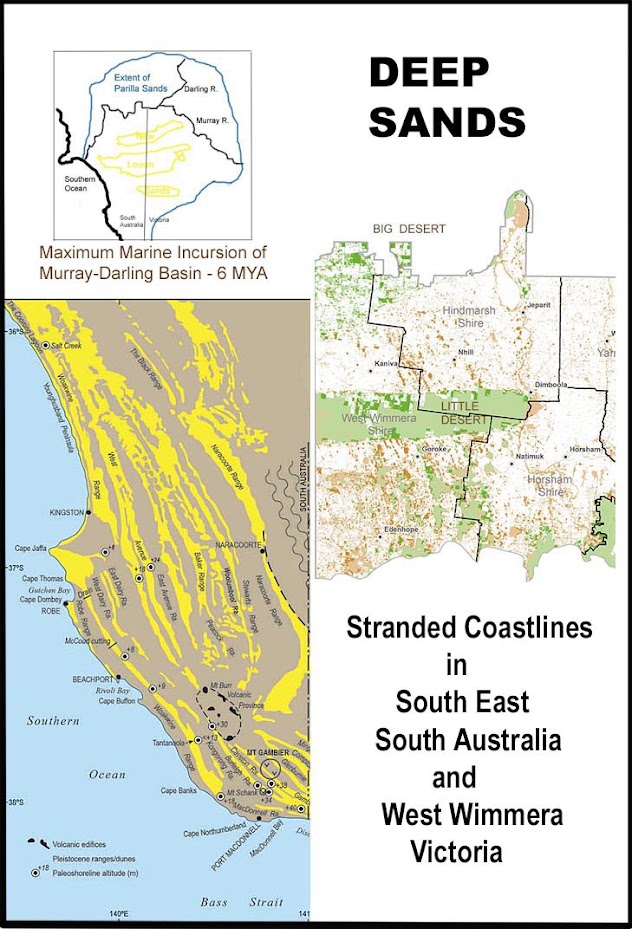
  Midway along the Highway from Melbourne to Adelaide, between Nhill and Kaniva, the road crosses a series of parallel sandhills. Lawloit Ridge is the steepest of these phenomena, which are actually "stranded coastal dunes". They are remnants of a geological past when much of the Murray-Darling Basin lay under the Southern Ocean. It was a time when global sea levels fluctuated according to a climatic cycle. Over millions of years, they fell when polar ice sheets froze (glacials) and rose when polar ice sheets melted (interglacials). The last period when marine flooding of southeastern Australia reached its maximum was approximately 6 million years ago (MYA).   1. 2018, 'Mallee Dunefields of the Murray-Darling Basin', ecological associates pty ltd, Kerang Vic.  2. 2016, CV Murray-Wallace, Coastal Landscapes of South Australia , Adel Univ Press, p 149.  3. 2022, Wimmera Catchment Management Authority, <wcma.vic.gov.au> Since that peak, the ocean has periodically r

CASUARINAS

Image
There are three main types of Casuarinaceae  growing in western Victoria. Ranging from the southwest coast (Southern Ocean) northwards to the Milewa Mallee, each species tends to occupy its own geographic zone. Nearest to the sea is the Drooping Sheoak, Allocasuarina verticillata, (formerly Casuarina stricta ), also called the Coast Sheoak. In the middle zone of the Wimmera is the Buloke, Allocasuarina luehmannii , sometimes spelled Bull-Oak. Farthest inland is the Belah, Casuarina pauper , (so-named because it is a smaller version of Casuarina cristata that occurs in New South Wales and Queensland). Drooping Sheoak, Buloke, and Belah also abut and cross over the border into South Australia. Casuarinas resemble pine trees with their needle-like foliage and woody seed-cases. The foliage is actually made up of segmented branchlets, with tiny blades (residual leaf tips) radiating from each joint of the thin stem. Their distinctive appearance is described in the word 'casuarina', w