Posts

Showing posts from 2020

An Underground Realm

Image
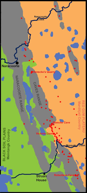
  The caves in the Naracoorte district are an unavoidable part of the local terrestial landscape. The surface of the Naracoorte Range, or more specifically, the Naracoorte East or Caves Range, contains numerous small entrances to a large and extensive honeycomb of limestone cavern systems below.  The attached map represents the cave entrances we are aware of today. Many of these access points have been dug out in modern times, but more obvious examples of cave falls and exposed chambers also abound. Within the traditional Caves Reserve of European times, the open experiences of the Blanche (aka 'Big'), Tomato/Sticks, Cathedral, and Bat Caves have always been known. Susan White & John Webb, 2015, 'The influence of tectonics on flank margin cave formation on a passive continental margin: Naracoorte, Southeastern Australia', Geomorphology , vol 229, pp  58-72 It is reasonable to assume that before their 'discovery' by British settlers in 1845, Indigenous people

MEINTANGK and MARDITJALI Placenames

Image
  When squatters John Robertson (Struan) and George Ormerod (Naracoorte) 'sat down' on their great 'sheep walks', they put their head-stations in the middle of two ancient pathways, special tracks that connected separate peoples. To the west lay black soil plains belonging to the Meintangk, pronounced me-in-tongue(k), called by descendants Moandik, and by some early chroniclers Moatunga. They were speakers of ( tangk ) a distinct dialect of the larger language group Buandik that populated most of the South East of South Australia from Mount Gambier to Bordertown (but not the Coorong). To the east lay the Red Gum country belonging to the Marditjali, speakers of ( jali ) a dialect of Jardwadjali, a language group that occupied the far west of Victoria around the Grampians ( gariwerd ), from Wimmera River in the north to Wannon River in the south. In between the territories of the Meintangk and Marditjali lies the Naracoorte Range, a natural boundary of raised limestone an

Dubious Selections

Image
  In 1891, a decade after John Robertson's death, his Struan legacy was described in a government summary as an "estate". Totaling 74,162 acres, it was spread over 4 Hundreds in the County of Robe: 21,277 acres in Robertson, 38,803 acres in Joanna, 9,201 acres in Jessie, and 4,871 acres in Comaum. [LG MacGillivray, 1982, 'Land and People: European Land Settlement in the South East of South Australia, 1840-1940', PhD thesis, University of Adelaide, Appendix 8] The significance of this figure lies in more than just its size. Struan was certainly large. But the acreage accumulated by Robertson also reveals a plan. His was a methodical, disciplined approach to acquiring freehold title, maintained over 3 decades. Of an initial 89,827 acres occupied under Pastoral Lease No. 169 in 1851 (Struan) and an additional run of 23,680 acres taken over in about 1858 (Wrattonbully), approximately 65% had been converted from leasehold to freehold by 1880. Crown Land, bought from th

On The Sheep's Back

Image
  The rise and fall of the Robertsons of Struan was relatively swift. Their pastoral dynasty 'achieved' in two generations what took others three or four. Between moving the first of the brothers' cattle and horses onto the New Country in 1844 and his death at Struan House in 1880, John Robertson forged a squatting enterprise that had few equals. Left to his four sons, John, Alec, William, and James, it shrank to a few thousand acres and a grand homestead taken over by the government in 1949. To fully appreciate the enormity of its collapse, it is necessary first to chart its growth in the nineteenth century -- to examine the economic factors that contributed to John's progress towards prosperity. His was a lifetime's work of 35 years, but he bequeathed a legacy that could not be sustained. Without access to the original 'station books', assuming that they even existed in the early days of the run, it is not possible to be precise. Information can only come