Posts

Karremarter Carnivores

Image
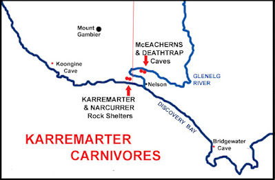
Karremarter is a small limestone shelter on the western edge of Discovery Bay. Set high on a ridge overlooking the coastal flats that surround the Piccaninnie Ponds sinkholes, it was occupied by humans during the Mid-Holocene. Relevant radiocarbon dates are 7,155-6,030 cal BP and 4,088-3,614 cal BP.  One of a number of similar sized rock shelters in the area, it is only a few hundred metres from Narcurrer Shelter, and shares many of the same range of bones from human prey species. "Debris started to accumulate in these small shelters once the sea level reached its present position and wetland and littoral resources were brought into close proximity". Sites like Karremarter and Narcurrer "were infrequently and opportunistically occupied ... brief stopping-over places for people moving along the coast or from the coast to the forested hinterland." 15 vertebrate species were identified at Karremarter, much mauled. "The taxa present, together with the degree of bon...

Constructing Hierarchy

Image
The eel fishery at Lake Condah is a well known site in Aboriginal archaeology, attracting respect and controversy in equal measure. Located on the Tyrendarra Lava Flow, it is an extensive system of water channels constructed in hard volcanic rock. A map drawn up by a colonial surveyor called Ingram shows a part of the scheme as at 1883. It identifies a dam at the Lake Condah outlet and gives it two labels: "Overflow dam Darlot Creek during winter" and "Wooden barrier or fishery". This neatly states the structure's dual purpose. It was built to control the flow of water and direct the movement of eels. The fishery is a complex network of inlet and outlet channels linking swamps and streams to create a flow between them. These man-made connections allow elvers (young eels) from the Pacific Ocean to migrate up the waterways into 'new' marshes and wetlands, where they 'fatten' for 15 to 20 years. The erection of stone and wooden weirs in the same cha...

Cultural Regionalism

Image
SOME CULTURAL PRACTICES START, SOME STOP,   SOME CHANGE, AND SOME DO NOT BONES HAVE A CLEAR AND DIRECT LINK WITH THE PAST: THEY REMEMBER IT Previous posts have described the first archaeological traces of Aboriginal settlement along the coast of southwest Victoria and southeast South Australia.  Sites at Cape Duquesne cliffs, Bridgewater South and Koongine caves, and Wyrie Swamp, have occupation remains dating from 13,000 to 9,000 years ago. They reveal an economic picture of subsistence existence during terminal Pleistocene ― Holocene transition, explaining diet and and the development of a "complete tool-kit" for practical survival. However, there is little among these artefacts that evokes their communal lives. Hunters and gatherers lived together, communicated with each other, had children and grieved the loss of family members. The difficulty is that only tangible elements are preserved long enough for archaeologists to dig them up millennia later. One way to gain ac...

Visible Archaeology

Image
Archaeology has a natural bias towards those parts of prehistory that are best preserved. Shell middens and stone tools do not decay with exposure and burial, but their resilience as signs of the past can skew subsequent interpretations about diet and technology. When a site reveals more perishable materials like wood or bone it is cause for celebration. Situated in the lower southeast of South Australia, Koongine Cave and Wyrie Swamp are two such places. Just 40 kms apart, both were occupied by Aboriginal people during the Terminal Pleistocene - Holocene Transition. A limestone cave and a peat swamp are different sorts of occupation site, but together they provide the earliest and most complete "tool kit" for subsistence survival along this part of the Australian coast. Radiocarbon dates for the use of Koongine Cave extend from 11,750-10,350 ybp to 10,250-8,200 ybp. Highest deposit rates are concentrated in the early phase of 11-10,000 ybp. Occupation during the later phase ...

Terminal - Transition

Image
  The first clear archaeological evidence for human occupation of the South West Coast of Victoria is from after the Meltwater Pulse (MWP 14,600-14,300 ybp), an event which marked the end of the long Last Glacial Maximum (LGM peak 22,000-19,000 ybp). The general post-MWP period is known as the Terminal Pleistocene, the end of the Pleistocene epoch, and as the Holocene Transition, the start of the Holocene epoch. While technically the Pleistocene finishes and the Holocene begins at 10,000 years ago, the Terminal-Transition stretches from 13,000 to 8,000 ybp. It is a broad timespan of prehistory covering the millennia of recovery, when the climate became wetter and warmer. In turn, plants, animals, and humans, all looked to expand their territory. There is an increase in human activity during this time, with new sites appearing in new areas. Prior to the LGM, the Victorian SW Coast and the adjacent South East Coast of South Australia seem to have been uninhabited, at least from an ar...

Long Glacial

Image
  Only a small part of Australia was actually glaciated during the Last Glacial Maximum (LGM), in the Snowy Mountains and Tasmania.  On the Kosciuszko Massif, terminal moraine dates at Blue Lake are between 22.3 thousand rears ago (ka) and 19.3 ka. At Cradle Mountain - Lake St Clair, Tasmania's largest Glacier at 27 kilometres (kms) long and 350 metres thick, dates are from 20.5 ka to 18.8 ka. Calibrated dating of most of the mainland and Tasmanian glaciers has indicated their greatest extent to have been from about 22,000 to 19,000 years before present (YBP). This date range gives a reasonably precise time frame for the most severe period of the LGM in Australia. Avoiding continental coverage by ice sheets was fortunate, but did not mean escaping a serious downturn in climatic conditions. Australia experienced a decline in average annual temperatures of up to 10⁰C and a 60% reduction in rainfall. Significant cooling and aridity produced a change in vegetation towards steppe-l...