Posts

Showing posts from June, 2022

Constructing Hierarchy

Image
The eel fishery at Lake Condah is a well known site in Aboriginal archaeology, attracting respect and controversy in equal measure. Located on the Tyrendarra Lava Flow, it is an extensive system of water channels constructed in hard volcanic rock. A map drawn up by a colonial surveyor called Ingram shows a part of the scheme as at 1883. It identifies a dam at the Lake Condah outlet and gives it two labels: "Overflow dam Darlot Creek during winter" and "Wooden barrier or fishery". This neatly states the structure's dual purpose. It was built to control the flow of water and direct the movement of eels. The fishery is a complex network of inlet and outlet channels linking swamps and streams to create a flow between them. These man-made connections allow elvers (young eels) from the Pacific Ocean to migrate up the waterways into 'new' marshes and wetlands, where they 'fatten' for 15 to 20 years. The erection of stone and wooden weirs in the same cha...
Cultural Regionalism

Image
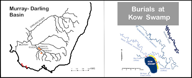
SOME CULTURAL PRACTICES START, SOME STOP,   SOME CHANGE, AND SOME DO NOT BONES HAVE A CLEAR AND DIRECT LINK WITH THE PAST: THEY REMEMBER IT Previous posts have described the first archaeological traces of Aboriginal settlement along the coast of southwest Victoria and southeast South Australia.  Sites at Cape Duquesne cliffs, Bridgewater South and Koongine caves, and Wyrie Swamp, have occupation remains dating from 13,000 to 9,000 years ago. They reveal an economic picture of subsistence existence during terminal Pleistocene ― Holocene transition, explaining diet and and the development of a "complete tool-kit" for practical survival. However, there is little among these artefacts that evokes their communal lives. Hunters and gatherers lived together, communicated with each other, had children and grieved the loss of family members. The difficulty is that only tangible elements are preserved long enough for archaeologists to dig them up millennia later. One way to gain ac...

Visible Archaeology

Image
Archaeology has a natural bias towards those parts of prehistory that are best preserved. Shell middens and stone tools do not decay with exposure and burial, but their resilience as signs of the past can skew subsequent interpretations about diet and technology. When a site reveals more perishable materials like wood or bone it is cause for celebration. Situated in the lower southeast of South Australia, Koongine Cave and Wyrie Swamp are two such places. Just 40 kms apart, both were occupied by Aboriginal people during the Terminal Pleistocene - Holocene Transition. A limestone cave and a peat swamp are different sorts of occupation site, but together they provide the earliest and most complete "tool kit" for subsistence survival along this part of the Australian coast. Radiocarbon dates for the use of Koongine Cave extend from 11,750-10,350 ybp to 10,250-8,200 ybp. Highest deposit rates are concentrated in the early phase of 11-10,000 ybp. Occupation during the later phase ...